That’s how our reader, Adam Feiges, describes this spooky view over South Dakota:
Adam Feiges
The badlands also get a mention in Jim’s cover story, when he’s describing the advantages of seeing the country from a low-altitude plane:
As you cross South Dakota from east to west, from the big city of Sioux Falls at the Iowa and Minnesota borders toward Rapid City and the Black Hills and beyond, you can see the terrain change sharply. In the East River portion of the state, between Sioux Falls and the Missouri, you see flat, well-watered farmlands and small farming towns. Then past Pierre you reach West River, with rough, dry badlands, some grazing cattle, and very few structures. Everyone who has looked at a map “knows” about the effect of topography and rainfall, but it means something different as it unfolds below you, like a real-world Google Earth.
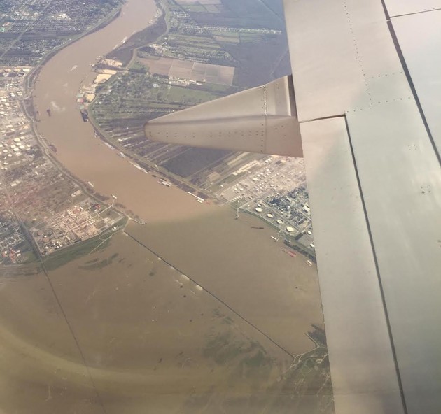
I took this photo shortly after departure from New Orleans on January 11. The lower part of the photo shows the Bonnet Carré Spillway, which had just been opened to divert excess water from the Mississippi River to Lake Pontchartrain. I was returning from the American Meteorological Society’s annual meeting, and it seemed fitting to have a chance to observe this rare event. I was struck by how many public agencies’ quiet, routine efforts resulted in an accurate forecast of water levels so that action could be taken to protect the citizens of New Orleans.
When opened, the control structure allows overflow volume to flow into Lake Pontchartrain. The lake’s opening to the gulf is sufficient to absorb and dissipate any conceivable volume of flood flow. Thus, the flood surcharge portion of the water from the Mississippi is divided between the main river and the diversion channel; with the surcharge bypassing the New Orleans metropolitan area, resulting in the Mississippi being lower (through that area) than it could have been; and reducing the stress on the area’s levees that line the river.
The spillway was built in response to the Great Mississippi Flood of 1927 that inundated much of the Mississippi River basin. It was first opened during the flood of 1937, and ten times thereafter through 2016 to lower river stages at New Orleans. The most recent opening began January 10, 2016, when river levels in New Orleans were predicted to approach the flood stage of 17 feet (5.2 m).
But Amy Wold, writing in The Advocate, Louisiana’s largest daily newspaper, calls the effects of the spillway a “mixed bag”:
In addition to sediment, the colder and fresher river water also carries nutrients from upriver agricultural practices, carries the possibility of invasive species and has at least the temporary effect of moving out certain species of fish that want more-brackish water. At the same time, the additional nutrients can provide a base for better growth of other species, the cold water may mean the impact on oysters will be lessened and nutrient blooms apparent in previous spillway operations may be delayed, if they happen at all. Only time will tell, because a January opening of the spillway hasn’t happened since 1937. Although not unprecedented, the early opening could mean different effects will be seen in the coming months.
Our reader captured this view “flying home from Shanghai in 2013, and I was blown away in seeing just how frozen Lake Erie could get in the dead of winter.” Frozen enough to walk clear across it, as Dave Voelker did in 1978:
To a novice, a winter walk across frozen Lake Erie to Canada is almost certain death. To a person trained in wilderness skills, it’s just a calculated risk— an uncommon sort of trip that might seem foolhardy at first impression, but which becomes more and more feasible with every map, depth chart and weather report that you study. At its narrowest, the lake’s width is only 30 miles — a comfortable two-day jaunt if you’re in shape. Most years, its surface freezes solid all the way across, to a thickness that will usually support a party of hikers. The biggest danger is that of exposure, since the barren surface offers no escape from the malevolent elements of winter, especially wind. Solve that problem, and you’ve got the whole thing licked.
When Lake Erie isn’t entirely frozen over, its icy waves often create, well, eerie sculptures against the shore. Recently, a whole car was encased in ice.
A reader sends a scene where it’s hard to tell at first glance what’s land and what’s water:
I love this idea. Here’s a photo taken from my home-built plane over the upper Mississippi River near Prairie duChen, WI. I’m sending from my cell phone, so let me know if it doesn’t turn out right.
Often referred to as Wisconsin’s second oldest city, Prairie du Chien was established as a European settlement by French voyageurs in the late seventeenth century. The city is located near the confluence of the Wisconsin and Mississippi Rivers, a strategic point along the Fox-Wisconsin Waterway that connects the Great Lakes with the Mississippi.
Early French visitors to the site found it occupied by a group of Fox Indians led by a chief whose name Alim meant Chien in French (Dog in English). The French explorers named the location Prairie du Chien, French for “Dog’s Prairie.” The American anglicized pronunciation is “prairie doo sheen.”
For our new photo series, reader Marco Pallotti happened to send a view captured on my 29th birthday—May 3, 2011—on a flight from Newark to Los Angeles:
In the foreground is snow-capped San Gorgonio Mountain, in the San Bernardino National Forest, with Mt. San Jacinto in the distance. In the valley between the two peaks is the town of Cabazon, and on the far left is the western edge of the Coachella Valley.
Fun facts about that forest: It was the filming location for Daniel Boone (1936) and Paint Your Wagon (1969). That area of Southern California also features prominently in Jim’s new cover story, specifically the nearby cities of San Bernardino and Redlands, his hometown:
When I was growing up [in Redlands], in the Baby Boom era, its economy rested on the orange-growing business, the neighboring Norton Air Force Base, and a medical community serving the nearby desert area. Now the orange groves are nearly gone, the Air Force base is closed, and the desert communities have their own doctors—but the city has been transformed by the presence of a tech firm that by all rights should be in some bigger, fancier place. This company, Esri, is a world leader in geographic information systems, or GIS. These are essentially the industrial-strength counterparts to Google Earth, which governments and companies around the world use for everything from tracking pothole repairs to monitoring climate change.