Pluto has long been a mystery, a dot at our solar system’s margins. The best images, even with NASA’s Hubble Space Telescope, were fuzzy and pixelated. In July 2015, NASA’s New Horizons spacecraft flew past Pluto and captured the sharpest views of the dwarf planet to date.
One of the most striking areas, informally named “Sputnik Planum,” is a sweeping, frozen plain the size of Texas and ringed by mountains of ice. Its smooth deposits are unmarred by impact craters, a stark contrast to the rest of Pluto’s battered surface. As a result, scientists believe the region formed recently, within the last few hundred million years. This contradicts past depictions of Pluto as an unchanging world.
The effects of land management are clearly visible in this image taken by the European Space Agency’s Sentinel-2 satellite on February 7th. The image uses near-infrared radiation, normally not visible to the human eye, shown here in red to highlight vegetation. The image spans roughly 34 km (21 mi) with South Africa to the west and Lesotho to the east. The dramatic national boundary is marked by an abrupt transition in landscape. Lesotho is a landlocked and mountainous nation; it is completely surrounded by South Africa on which it is economically dependent. The Lesotho lowlands, once essential for sustenance agriculture, have been farmed and grazed intensively over the last century. This has resulted in a degraded landscape characterized by “dongas”, dry erosion gullies, and severe soil erosion.
But the archipelago is also the lowest nation in the world, so it’s under existential threat as sea levels continue to rise worldwide. NPR’s Geoff Brumfiel reported yesterday on a depressing new study:
“Sea level rise in the 20th century was truly extraordinary by historical standards,” says Bob Kopp, an associate professor of Earth and planetary sciences at Rutgers University, and who is lead author on the study, which appears in the journal Proceedings of the National Academy of Sciences. Sea levels rose by roughly 5½ inches in the past hundred years, Kopp says, noting, “That’s faster than any century since at least 800 B.C., since the founding of Rome.” ...
Looking forward, Kopp and his co-authors predict things are going to get worse. The team’s findings suggest sea levels will rise between 1 to 4 feet by 2100.
If that isn’t bleak enough, NASA just posted a GIF illustrating the melting glaciers in Patagonia’s Sierra de Sangra, an icy stratovolcano spanning the border of Chile and Argentina:
The first image shows the glaciers of Sierra de Sangra on January 14, 1986. The second image shows the area on January 14, 2015. Snow and ice are blue in these false-color images, which use different wavelengths to better differentiate areas of ice, rock, and vegetation. … [T]he southeast outlet glacier retreated the most—about 1200 meters, or 25 percent of its length. The north outlet retreated by about 700 meters; the south outlet by 700 meters; and the east outlet by 300 meters.
MODERN MILITARY CAMOUFLAGE traces its origins to World War I, when the French army gathered a cadre of artists in three top-secret workshops near the western front. The blotchy smocks they created sparked the popular imagination. Camouflage was not issued widely, though, because of the high cost and low production capacity: every yard of camouflage was a hand-painted work of art.
U.S. marines in the Pacific wore industrially manufactured camouflage during World War II, but its use was limited in Europe because German paratroopers were known for their camouflage uniforms, and American officials didn’t want confusion to cause fratricide. Camo uniforms were more widely issued to U.S. troops in the early 1970s, when jungle prints provided immediate advantages in Vietnam. Patterns and colors evolved during the ’80s and ’90s, but the basic look remained the same: green and brown—striped, swirled, and blobbed.
One commenter asks, “What planet is that @nasa?” According to their website:
The Turpan Depression, nestled at the foot of China’s Bogda Mountains, is a strange mix of salt lakes and sand dunes. It is one of the few landscapes in the world that lies below sea level.
These environmental #satellites can measure outside the visible range of light, so these images show more than what is visible to the naked eye. The beauty of Earth is clear, and the artistry ranges from the surreal to the sublime. Truly, by escaping Earth’s gravity we discovered its attraction. Earth as art—enjoy.
Here’s a view of Cyclone Winston yesterday just before it became “the strongest landfalling tropical cyclone on record in the South Pacific archipelago” of Fiji:
The cyclone has since killed at least 10 people and destroyed hundreds of homes in the small island nation, according to the Weather Channel. More from the AP:
[UNICEF spokeswoman Alice Clements] said there was foliage everywhere that looked like it had been put through a blender. About 80 percent of the nation’s 900,000 people were without regular power, although about one-third of them were able to get some electricity from generators, said Dregaso, the disaster office official. [...]
The government declared a 30-day state of natural disaster, giving extra powers to police to arrest people without a warrant. The government said the curfew would end at 5:30 a.m. Monday. “The curfew has been imposed to protect lives and protect property,” Prime Minister Bainimarama said in his address.
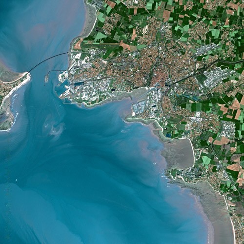
The European Space Agency has a great caption for this watercolor-like view of a coastal French city:
This is La Rochelle, capital of the Charente-Maritime department in western France. La Rochelle sits on layers of limestone dating back some 160m years, when a large part of France was under water. 💧 The coastal area is dominated by sandy beaches, which are visible as white lines. Between the beach and the water-line, we can see darker sand and silt layers. The 4–5 m tidal range creates a heaven for wild mussels and oysters, making it one of the major places for shell farming in Europe.
Thanks to the high-resolution multispectral instrument on Sentinel-2A, we can clearly make out the various agricultural fields around the city and surrounding towns, as well as on the Île de Ré Island. 🌴 Part of the Natural Reserve of the Bay of Aiguillon is visible at top right. It is one of the most important reserves in France, hosting hundreds of thousands of migratory water birds every year.
This is a place of synergy between land and sea, between saltwater and freshwater, and between nature and humankind.
A more inland view of La Rochelle, from SPOT Satellite (via Wiki):
A photo posted by Daily Overview (@dailyoverview) on
PBS’s American Experiencedetails Hoover’s role in the dam’s creation, first as a Cabinet official:
During the time in the early 1920s when legislation was being crafted to authorize a dam on the Colorado River, Herbert Hoover served as Secretary of Commerce for President Warren Harding. Hoover was present at many of the early meetings that focused on how water would be allocated among the seven states (Arizona, California, Colorado, Nevada, New Mexico, Utah, and Wyoming) involved in the project. There was much disagreement over what constituted a fair distribution of water. … Hoover was congratulated for his skill and efficiency in handling the matter. At this point in his career, Herbert Hoover was growing used to such praise.
Then later, as president:
As unrest caused by the Depression increased, Hoover’s interest in what was then being referred to as the Boulder Dam project increased. Eager to diminish the unemployment rolls, Hoover pushed for commencement of the project.
On September 17, 1930, Ray Lyman Wilbur, Hoover’s Secretary of the Interior, journeyed out to the Nevada desert to drive a silver railroad spike to mark the project’s official beginning. In doing so, Wilbur issued a statement that would be a source of derision and controversy for the next 17 years. Proclaimed Wilbur, “I have the honor and privilege of giving a name to this new structure. In Black Canyon, under the Boulder Canyon Project Act, it shall be called the Hoover Dam.” Those who were convinced that Hoover’s inaction had worsened the Depression scoffed at what they saw as political showboating and opportunism.
Dam construction did indeed create thousands of greatly-needed jobs, but it was not enough to rescue the political fortunes of Herbert Hoover. In the 1932 presidential election, he was soundly trounced by Franklin Delano Roosevelt. Eight days after his defeat, Hoover traveled to visit the construction site of the dam he had done so much to make possible. Whatever solace Hoover took in knowing that a remarkable monument of industrial genius would bear his name was short-lived, however. In 1933, newly appointed Secretary of the Interior Harold Ickes renamed the site Boulder Dam. Not until 1947 would Congress pass an official resolution declaring the site as Hoover Dam.
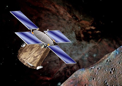
Twenty years ago today—on February 17, 1996—NASA launched into space an unmanned aircraft named NEAR, or Near Earth Asteroid Rendezvous. Its primary mission was to gather information about asteroids, as explained on the NASA Discovery website:
The mission was designed to answer many fundamental questions about the nature and origin of asteroids, which are of great interest both because of their potential for colliding with Earth and for the clues they hold about the formation and evolution of our solar system.
The NEAR launch didn’t immediately go as planned. From an AP report that day:
CAPE CANAVERAL, Fla. — Equipment trouble forced NASA to delay the launch of a spacecraft toward an asteroid Friday. Managers halted the countdown with less than an hour remaining because of problems with the safety system used to track ascending rockets. They said they would try again today to launch the unmanned Delta rocket from Cape Canaveral Air Force Station. Once launched, the spacecraft--called [NEAR]--will spend three years flying to the asteroid Eros and then become the first spacecraft to orbit an asteroid.
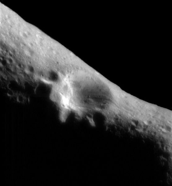
NEAR entered into orbit around Eros on February 14, 2000, and Michael Benson wrote about the union for a 2002 issue of The Atlantic. He described the craft’s landing on Eros “not unlike an adolescent confronting the object of his or her erotic fascination for the first time”:
NEAR's first image from Eros orbit (NASA)
In early 2000, in an event largely ignored by the mainstream media, the Jet Propulsion Laboratory eased [NEAR] into orbit around a twenty-one-mile-long peanut-shaped, methodically tumbling rock called Eros. NEAR was the first spacecraft ever to orbit an asteroid—no inconsiderable feat of celestial navigation, given that Eros has a gravity field so weak that an astronaut on its surface could reach escape velocity by simply jumping off. A year later project scientists maneuvered the probe to within a few hundred yards of its subject and then directed it to touch down gently. NEAR thus became the first spacecraft to land on an asteroid.
NEAR hasn’t performed flawlessly. Not unlike an adolescent confronting the object of his or her erotic fascination for the first time, the spacecraft suddenly flipped out during its initial approach to Eros, in December of 1998. Cut off from communication with Earth, acting on its own, the probe's computer managed to re-orient the spinning craft. But by the time the JPL flight engineers had figured out what went wrong, they were forced to send their charge all the way around the Sun again-a year-long trajectory-for another try.
They wouldn’t have been able to do so if NEAR hadn’t straightened up and flown right all by itself. There’s something fascinating about the increasing autonomy of these robots with which we’re populating the heavens.
NEAR Shoemaker [as the craft was renamed] now rests silently just to the south of the saddle-shaped feature Himeros as the asteroid twists more and more away from the sun with each rotation, moving the southern hemisphere into its winter season and temperatures as low as minus 238 degrees Fahrenheit (minus 150 centigrade). … Tonight at 7 p.m. (EST) NASA’s Deep Space Network antennas will pull down their last Near Earth Asteroid Rendezvous (NEAR) mission data, bringing to a close the first mission to extensively study an asteroid. NEAR, which was the first mission in NASA’s Discovery Program of low-cost, scientifically focused space missions, and the first to land on an asteroid, has delighted astronomy neophytes and scientists alike.
The seeds of canola flowers are crushed for their oil, which is used for cooking and biodiesel. Daily Overview’s Benjamin Grant has also posted a vibrant view of rapeseed fields surrounding Soest, Germany. What’s the difference between rapeseed and canola? Not much, as The Kitchn’s Ariel Knutson explains:
Canola was created through plant-breeding in order to get rid of two undesirable components of rapeseed. Rapeseed oil and canola oil also get mixed up because they can be labeled incorrectly outside of Canada and the United States. In the 1970s canola was created through traditional plant cross-breeding by removing two things found in the rapeseed plant: glucosinolates and erucic acid. Erucic acid was removed because it was believed to be inedible or toxic in high doses. The newly developed plant was renamed “canola” – a combination of “Canadian” and “Oil” (or ola) to make this difference apparent.
And to get rid of “rape,” which is derived from the Latin for turnip (rāpa or rāpum) but isn’t the most marketable consumer name.
In Boston, thermometers dipped to minus 9 degrees — the coldest day since Jan. 15, 1957, according to The Weather Channel — while in New York City, Central Park registered minus 1, the lowest reading in 22 years. So it went from Newark, New Jersey, to Hartford, Connecticut, to Watertown, New York, where temperatures plunged to a staggering (and all-time record) minus 37 degrees.
Winter Storm Olympia will continue to produce hazardous travel conditions as it spreads snow and a wintry mix through parts of the East for the start of the week. During the weekend, Olympia brought snow to Midwest, resulting in several multi-vehicle accidents. [CB note: Two people were killed in Minnesota.] The storm has now caused multiple accidents across North Carolina due to icing Monday morning. Various winter weather advisories, winter storm warnings, winter storm watches and freezing rain advisories have been issued by the National Weather Service for Olympia, extending Maine to northeast Georgia. Although precipitation may start as snow or ice in the East Monday into Monday night, many locations will change to rain during the course of the storm, including along the I-95 corridor.
Crater Lake is located in Fort Klamath, Oregon, USA. The awe-inspiring, deep blue water sits in a crater that was formed 7,700 years ago by the collapse of a volcano. Rain and snowfall compensate for any evaporation as no rivers flow into or out of the crater.
I once rode a bike around the 33-mile Rim Dive that encircles the lake, and one of the most notable parts of the landscape is one of its smallest—a spooky tree trunk that’s been floating vertically in the lake for more than a century:
The first record of the Old Man’s presence was made by Joseph S. Diller in 1896. According to his records, the strange, vertically floating log was splintered and bleached white, measured approximately two feet in diameter, and, at four feet above the water line, was substantial enough for a man to stand on. Moreover, the crystal clear water showed that the former tree’s roots were still intact below, making the Old Man appear rooted to the spot, despite Diller having spotted the stump a second time over a quarter-mile from its original location!
To this very day, all of the above remain true.
In the subsequent century, a few more details have emerged. Scientists believe the 30-foot long hemlock was washed into the lake via landslide, though debate continues to rage over the exact mechanics pertaining to the tree's vertical positioning. The most-accepted theory is that the tree once had rock tangled within its roots. By the time the roots decayed enough to drop the rocks, the wood beneath the waterline had absorbed water, whereas the four feet of trunk above water had dried out, thereby creating the unique, perpetually upright orientation!


,_Crater_Lake,_OR.jpg)