Tv in the Cockpit: The Control of Landing Aircraft
Now flying B-707’s on round-the-world flights to the Far East, MARIUS LODEESEN learned to fly with the U.S. Navy at Pensacola, Florida, after getting his master’s degree in aeronautical engineering. He was a member of the crew of the CHINA CLIPPER on the first transpacific flight from San Francisco to Guam in 1935. He has more than thirty years of experience as an airline pilot and executive.
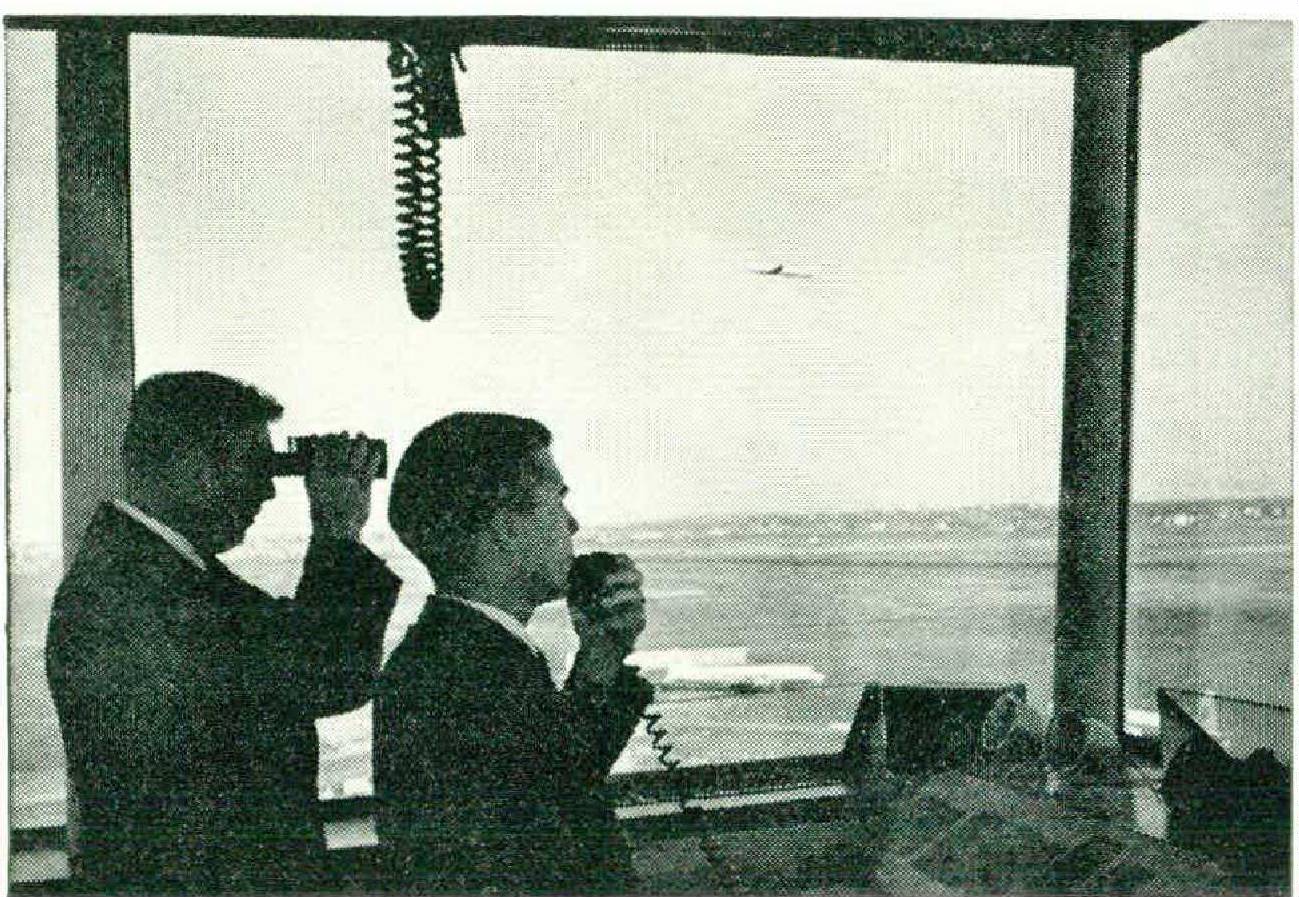
THE shadows are lengthening, the last rays of the sun caress the wings of a jet airliner as it speeds homeward near the end of a transatlantic voyage. In the cockpit the crew sits relaxed — Big Brother is watching over the flight.
“Flight X, we have a traffic advisory for you. A B-52 will be crossing your track from left to right, one thousand feet above your altitude.”comes the voice of the radar ground controller. Three pairs of eyes peer ahead.
“There he is!” calls the second officer. “There, at ten o’clock.” Penciled against the sky, a black silhouette draws near, crossing the bow of the airliner so close the crew can read the insignia on the bomber’s fuselage.
“Radar, have you another aircraft on your scope?”
“Negative,” answers radar.
Jet Flight ZYZ is cruising in brilliant sunshine.
“Hey, what’s that? I saw something out of the corner of my eye,” exclaims the first officer, looking up from copying weather sequences.
“That,” growls the captain, “was a jet passing us at spitting distance. I think I recognized the skipper.”
“Radar from Flight ZYZ, we nearly centerpunched another airplane. Ho you see him?”
Radar had not.
Airplane traffic above a busy airport has been compared to a bottle full of flies. But flies know where they are going. Pilots do not. We are haplessly led about by a voice from the ground, a voice coming from a figure hunched over a radarscope. Every blip on that screen represents a six-milliondollar machine and a hundred or so lives. Pilots feel trapped, like flies in a bottle.
Aircraft traffic is being controlled over the airways much as it has been done for twenty years. Airplanes cruise between radio beacons as ships steer through a buoy-marked channel. These beacons allow pilots to fly radial courses by means of a direct indication in the cockpit. Pilots jump, in a manner of speaking, from one beacon to the next. Airways are twenty miles wide, and they have to be, because of errors of radio stations, aircraft receivers, and instruments. Radar stations scattered over the country assist pilots to keep separation, while precision radar at airports guides planes to runways.
But the present control system, already stretched to the limits of its potentialities, fits future requirements about as well as a grass airfield suits a jet transport. The aximuth (angular) error inherent in this system prevents close parallel tracking. Railroads cannot operate without parallel tracks, nor turnpikes without multiple lanes; nor are aerial highways practical in the jet age on a single Toonerville trolley right-of-way.
In 1960 there was a ghastly collision over Brooklyn of a Douglas DC-8 and a Constellation, both planes under radar surveillance. In February of this year two jet transports missed each other by the narrowest of margins at thirty-three thousand feet, an altitude to which both aircraft had been assigned by Air Traffic Control. Only a few days earlier, a radar operator steered a Boeing 707 directly into a severe thunderstorm, causing the destruction of the airplane. Near-misses — those that are reported — occur at the rate of several daily. In this jet age, pilots fly at near sonic velocity, talk with machine-gun-fire rapidity, and stretch human endurance to the yield point.
To stake everything on radar and, in the final instance, on the human operator seems as foolhardy as taking off on an overocean flight without considering an alternate airport, in case the destination is weather-bound. Aloft, we constantly check and recheck, never relying exclusively on one mechanism or human action. If our landing gear does not come down with normal hydraulic pressure, we crank it down by hand. If one or even two power plants fail, we can manage on the remaining ones. If one pilot drops dead, there is another one to carry on.
With radar control it is all or nothing. What if a tube burns out? What if rain or snow blots out our blips? What if an overburdened operator makes just one split-second decision the wrong way?
Deficiencies of word-of-mouth navigation are clear. The human voice is an imprecise tool. There are slips of the tongue. On almost every flight operators can be heard telling a pilot to make a right turn when a left turn is indicated, or the pilot misunderstands and turns in the opposite direction. A voice is transitory, elusive, here one moment, gone the next. So are the blips on the screen, sometimes fading out within radar’s range when planes fly through heavy rain, snow, or clouds.
A ground operator’s perspective differs from that of the man in the air; his professional background is not comparable to that of the airline captain. The storm raged for years on the merits of GCA (talk-down by ground operators) versus ILS (approach system without assistance from the ground). ILS fortunately won this battle, though not before many of us had collected some startling experiences when heavy rain removed our blips from the radarscope or when the GCA first team was out to lunch. A radar operator’s affiliation with those blips is of a detached, objective nature. “Nobody,” remarks my friend and colleague Gordon Wood, “has ever been killed in a radar operator’s chair.”
And what does it really mean when a pilot is advised of a “high-speed target, opposite direction, altitude unknown”?
Normally his eyes scan an empty sky, but it could be that this plane is boring directly at him. “Opposite direction” assumes the aircraft is on a collision course; “altitude unknown” means that it might be at his level. “High-speed” implies it is a jet moving from six hundred to fifteen hundred miles per hour, or at a minimum closing rate of five miles in fifteen seconds. Even if the pilot can see the other plane, evasive action might lead to a crash.
A few months ago, over Belgium, my own aircraft met a supersonic Hustler. When I saw the four-engine blowtorch ahead, my hand reached instinctively for the autopilot turning knob, but before I could move it, the jet bomber flashed by. What purpose is served if the pilot is told that another aircraft is near without knowing its altitude or what action should be taken to avoid it?
If we persist in putting our faith in radar, we will be buying questionable safety at great cost. From rough calculation, it appears that at least one hundred radar stations will be needed to watch and direct the estimated twenty thousand daily air movements in the upper airspace over the United States. Assuming that each target needs a controller to look at raw radar and one for height radar, and that en route controllers take on several planes at once while precision controllers take on only one at a time, about two thousand men will be at the scopes continuously.
For every man at the controls, there may need to be five in the background: one resting between watches, one asleep, two shopping or baby-sitting, and one sick or on leave. Approximately ten thousand controllers will be needed to look at the upper levels, not to mention the middle and lower airspace. A tiny announcement appeared in the newspapers recently stating that the Federal Aviation Agency was beating the bushes for twenty thousand more radar operators.
Few will dispute that the price of this sort of control is high. But price is no deterrent when safety is at stake. Radar’s gravest fault is that it turns the commander of the aircraft into a hapless marionette. The captain’s responsibility cannot be diluted; it must be restored to the flight deck.
FUNDAMENTALLY, we need a device in the airplane with which we can check our position, a device giving us an accurate indication of our position relative to our surroundings. A glance should tell us where we are, where we have been, and where we want to go. A picture is worth a million words. This is what pictorial navigation does for the pilot; it takes the mental picture out of his head and puts it on a map before him.
Such systems are available now and have been for years, but not on this side of the Atlantic. To get the lowdown on a system which does fit the bill, I drove to Gatwick Airfield, southwest of London, for a briefing. I was eased into an armchair, offered a cup of tea and a cigar, and exposed to a course in visual navigation. Here is how it works.
A road marker on a highway shows you the direction of your destination and the distance to it. All you know is that the road will take you there and how far you have to go. For more, a road map must be consulted. This is essentially the kind of navigation we use today.
Now, if someone sits beside you with a map on his lap and traces with a pencil the progress of the car, you can, by glancing at the chart, see where you are, how far you have come, other roads, cities — in short, the total picture. If you replace this person with an electronic setup, mount the map on rollers, and have a pen trace your path, then you have what hyperbolic navigation can do for the man in the cockpit.
Hyperbolic navigation is based on groups of ground stations emitting signals which produce a lattice of lines of position in space. The lines are shaped like hyperbolas, hence the name. As the aircraft flies through this cover, its receivers translate the information to a moving pen drawing the track on a rotating chart. The system is suited to long-, medium-, and short-range and to highand low-level navigation as well. Surface ships also use it.
Several cups of tea and cigars later, my informant suggested we try the navigational system in the air.
“Let us simulate a search problem,” said Captain Cameron, my pilot, handing me an ordinary map of southeastern England. “Just select a point on this map.”
I chose a water reservoir we often use as a landmark when approaching London airport. Cameron transferred this point to the flight log (revolving chart) and placed the pen on our starting position. We cranked up the engines, took off, and the pen began to draw our path on the chart before us.
Cameron set course for the reservoir just as someone would steer a boat to a distant lighthouse on shore. When the stylus arrived over the point he said, “Now look over the side and see where we are.”
Sure enough, we were directly over the center of the body of water. He then flew away, made some random maneuvers, and returned to the identical spot, centerpunching the water area.
“Not only can we find a spot a hundred miles away with a tolerance of a few yards,” explained my mentor, “but we can take this chart, mount it in any other airplane, fixed-wing or helicopter, and any pilot can take off from anywhere and pinpoint this reservoir.”
“I see your point,” I said. “In other words, you could have aircraft flying at identical altitudes in close proximity, if the accuracy is as good as you say.”
“Precisely; in fact we are doing just that. We direct aircraft to fly along either side of a ten-milewide airway in opposite directions at the same altitude, like motorcars on a turnpike.”
Over the Atlantic Ocean the long-range system is so precise that up to a range of fifteen hundred miles the greatest tracking error is only a few miles. As the airplane covers eight to ten miles a minute, what greater precision could be desired? I have seen the pen trace our track across the North Atlantic just as neatly as our navigator draws our course on his navigation chart.
Around busy airports this system really comes into its own. Instead of flying blindly about, the pilot is driving in full control, without mental gymnastics. When waiting for landing clearance, for example, when things are a bit sticky down below, we are stacked up over gateway radio beacons at one-thousand-foot intervals vertically, drawing a pattern in the form of a racetrack over the holding beacon.
If a pilot is holding with a dozen other airplanes over the same beacon, above the cloud deck, presumably flying identical patterns, he normally sees only two or three of the other planes. The others are somewhere off in the boondocks.
With an automatic picture display before him, he can see where he is, fly his airplane, and smoke his pipe if he is so inclined. Pictorial navigation thus allows close parallel tracking on airways, takes the guesswork out of close-in approaches, and reduces considerably the mental work load on pilots. What it does not do is to show other aircraft. For this we still need radar monitoring control.
Let me emphasize that professional pilots are grateful for ground radar. We owe a good deal to radar when our cockpit navigation fails or during emergencies. The occasional radar vector is also welcome to keep proper separation on the airways. We admire and respect the superb tongue-twisting performance of our scope-watching colleagues, whose functions are prodigious. The pressure under which these men work is altogether too strenuous. It is not even necessary.
One of the more articulate airmen is Captain Charles F. Blair, Harmon Trophy winner and recipient of the Thurlow Award for outstanding contributions to the science of navigation. The P-51 single-seater in which Blair flew over the North Pole in 1951 hangs in the Smithsonian Hall of Fame. His twenty-eight thousand air hours include more than one thousand Atlantic crossings and thousands of hours in commercial jets and Air Force fighters from the F-100 to the F-110. This is what he wrote in Interavia, and he speaks for many: “Any analytical pilot can tell you, this technique of navigating by word-of-mouth is turning out to be the essence of navigational folly in civil air transports. In the U.S.A. special interests won the battle dictating that high-frequency radio beacons would do the job despite the countless problems introduced by the jets. The ground-oriented experts searching for precision not afforded by this method came to the conclusion that ground radar must solve everything, even our cockpit navigation. The final brush-off was an inconclusive, abbreviated test of a Pictorial navigation facility still causing informed Americans to squirm with embarrassment.”
Here Blair refers to the grim tug-of-war which took place in 1959, behind the scenes and even on the stage, at the meeting of the International Civil Aviation Organization (ICAO) when it came to choosing a standard world navigation aid. The carefully analyzed requirements formulated by such authoritative bodies as the Curtis Committee, the Jet Operations Panel, and the International Air Line Pilots Association came to nothing.
The bitter truth is that our problems are not going to be cured by ground radar, which we already have in busy areas. No matter how perfect the machinery, its performance still hinges on the human element. We need closer parallel tracking within our airway structure, and we cannot have it with our present equipment.
Europeans place their hope in a new organization named ELROCONTROL. This supranational organization sponsored by Great Britain, France, West Germany, and the Benelux nations is dedicated to the study of navigation systems. The directorate is determined to evaluate all proposals without pressure from national or business interests and submit the results to the ICAO. A navigation system can be adopted on a worldwide scale only by a two-thirds majority of the council of the ICAO. We wish them luck.
Before we can extricate ourselves from this danse macabre, our national policy must be purged of the false presumption that what was good enough for propeller aircraft is good enough for jets. We must dispense with the continuous inoculations that make us content with facilities producing singletrack airways. Last, a fair and imaginative test of a pictorial navigation system must be made by a qualified organization using pilots free of heelclicking subservience.
What would a pictorial display do for us that we cannot do now?
It would give us a foolproof airway structure with continuity and push-button navigation.
It would get rid once and for all of the chaotic confusion of radiotelephony, which makes airport approaches hell in the sky.
It would restore responsibility to the captain of the aircraft, where it belongs.
Can we afford to settle for less?