

Go to this issue's Table of Contents.
J A N U A R Y 2 0 0 1
 HE petroleum industry and the computer have been closely connected for many decades -- since the years when a computer was a human being calculating as fast as he could. Along with the space program and a few other endeavors, the oil industry has been elemental in driving computing technology forward, because petroleum geologists' appetite for processing power is insatiable. It is no accident that Texas Instruments, one of the pioneers in the computer business, was born in 1930 as Geophysical Service, a company that provided seismographic data to the oil industry.
 There is nothing new about seismic imaging. The basic technology is not particularly complicated. Oil lies deep underground, trapped in the pores of rock at enormous pressures, and rock is a good conductor of sound. Knowing how fast sound travels, geologists can set off booms or pings and then analyze the returning echoes to infer the nature and location of the surface that has reflected them. Submariners have used this trick for decades; bats have used it forever. By the 1930s seismic imaging had established itself as a central technology in the oil business. Geologists would set off a boom and use mirrors to project the resulting vibrations onto photographic paper. Today the surveys use geophones wired to digital recorders, but the principle is the same.
For many years the most that computers could handle was two-dimensional imaging, which showed vertical cross sections of rock. Even 2-D created no small headache for computers. In a typical smallish 2-D survey of twenty or thirty square miles, engineers would lay out a line of hundreds or thousands of geophones and set off a bang. Then they would record the echoes, move the geophones or the sound source, and bang again. (At sea the detectors would be dragged behind boats that detonated air-gun booms every ten seconds or so.) The process would generate several million echo traces -- but such traces by themselves tell nothing about the structure of the earth. All the rest must be done by mathematical inference. The computer's job is to construct the mathematical model of the underground structures that seems most consistent with those millions of echoes; each echo must be disassembled into thousands of milliseconds, and each millisecond must be compared with many others and analyzed in several different ways before any sort of picture begins to emerge. With 2-D the picture was crude and, of course, two-dimensional.
Geologists long yearned for three-dimensional imaging, which would let them look inside the earth from any angle, but the computing requirements were staggering. With 3-D the number of possibilities that the computer needs to sort through increases by orders of magnitude. Even a small 3-D survey might easily generate 200 gigabytes of data, and all the data points would then need to be analyzed from every direction simultaneously. In 1975, 3-D seismic imaging came into its first commercial use, but it was too slow and expensive to do anyone much good.
That is what the processing revolution changed. From 1985 to 1995 the computing time needed to process a square kilometer's worth of data fell from 800 minutes to ten minutes. From 1980 to 1990 the cost of analyzing a fifty-square-mile survey fell from $8 million to $1 million. Now it is more like $90,000.
 In 1989, according to the U.S. Department of Energy, only five percent of the wells drilled in the Gulf of Mexico made use of 3-D seismic data; by 1996 the figure was 80 percent, and the surveys themselves were more sophisticated. Today that smallish twenty- or thirty-square-mile survey might easily involve 25,000 geophones, 2,000 echo traces per shot, and 30,000 shots -- a total of more than half a million floppy disks' worth of data, or more than 800 gigabytes, of which each byte must be compared and reconciled with thousands or millions of others. Over the past decade seismic analysis has increased its data-gathering and data-processing requirements by an order of magnitude every five years, and no end is in sight. Schlumberger, a big oil-technology company, recently announced a higher-resolution technology, called Q, that gathers several times as much data as anything before and pushes computers proportionately harder.
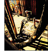
The easiest way to appreciate the results is to go look at them. A good place to do that is at Magic Earth, in Houston. Magic Earth is what is known as a 3-D seismic visualization facility, one of many that have appeared in the past three years. "Engineers sit in front of this," Michael Zeitlin, Magic Earth's president and CEO, told me one day last spring when I stopped by for a demonstration, "and have an emotional response."
Zeitlin has been in the oil business for twenty of his forty-two years. He is originally from New York City, but his manner is all West Coast. We were sitting in a glass cube of a building, in whose center stood a twenty-five-foot-high metal pod, like a shiny mushroom cap. Zeitlin talked with the rat-a-tat energy of an entertainment-industry executive, which he could almost be. Hollywood uses digital imaging and supercomputers to bring dinosaurs and typhoons and starships to life; Zeitlin does the same thing for structures deep in the planet, structures that will never be seen by any human eye.
Vision, Zeitlin explained, requires a great deal of bandwidth. To generate the illusion of motion requires fifteen to twenty frames a second. In the 1980s geologists' computers couldn't calculate that fast; in the 1990s they closed the gap, and then some. High-end computers can now take terabytes of seismic data and create vividly colored three-dimensional images of them; and they can generate those images at a rate of up to sixty a second -- fast enough to fool the brain into thinking that it is panning through the interior of the planet, seeing formations that are miles underground in much the same way one might see the Grand Canyon from a moving helicopter.
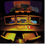
Zeitlin showed me into the pod. On the way to the viewing room we passed the brains of the place, a Silicon Graphics mainframe. At the front of the pod was a large curved screen, eight feet high, twenty-five feet wide, and wrapping 160 degrees, to envelop the viewer. In front of the screen was a conference table, where I took a seat. Behind me was a technician running the computer.
Zeitlin began with some familiar images: a Flintstones car, which we viewed from every angle, and the Matterhorn, which the "camera" (really the computer, manipulating its banks of data to create the image in real time) flew around at the command of a mouse. And then we were underground, about 6,000 feet below West Texas, and the image before me was a translucent cube of planet, colored to show the geologic features of the subterranean landscape. Zeitlin pointed to a blue patch that meandered like a river. It was an ancient channel, he said, cut eons ago and long since buried beneath a mile of sediment. He gave me the mouse, and I found myself clumsily rotating the image, viewing it from above and below and then moving inside it. You can put on 3-D goggles and the image onscreen becomes fully three-dimensional, springing to life like a hologram. You can peel the earth in layers a few dozen feet thick to reveal horizon after horizon of primeval topography. With a mouse you can draw a virtual oil well into the picture, so as to "see" the well long before it is drilled. At certain other visualization facilities the images are projected on the walls and floor and ceiling of the viewing room; wearing 3-D goggles, you can walk through the interior of a formation, as if through a cave.
So compelling is the illusion created by visualization technology that I had to forcibly remind myself that none of it is either real or even a photographic image of anything real. It is all mathematics -- models of the earth built by computers from echoes and algorithms. One forgets, too, that the sci-fi wizardry of a place like Magic Earth is not the computer's most impressive feat in the remaking of the oil business.
That feat occurs in, among other places, an almost bare room in Houston, not far from Magic Earth, where a business called Newfield Exploration Company has its offices. Newfield is a fairly typical independent oil company. It was founded in 1989 and is capitalized at $2 billion, with revenues of $400 million, which makes it substantial for an independent but much smaller than the majors. It specializes in buying properties that the majors no longer regard as profitable and finding -- as Gary Packer, one of the company's petroleum engineers, puts it -- "new fields within old fields." The company is able to do this by buying 3-D seismic data and poring over it, looking for meat that the majors left on the bones.
I asked to see where the magic happens, half expecting to see more supercomputers and giant curved screens. I was led down an unadorned hallway to a room containing a light table, two large-screen monitors, and two middle-aged men in white shirts and ties. Tom Adams is a geologist, and Eric Freeman is a geophysicist, and they were prospecting for oil in Texas. The monitors buzzed with zebra-stripe patterns. Colored lines showed faults, and here, the men said, pointing, was a "bright spot" -- a place likely to harbor hydrocarbons. Newfield was using off-the-shelf desktop software that was not remotely as powerful as the proprietary program that runs Magic Earth's supercomputer-driven light show. Still, the software allowed Adams and Freeman to examine in detail nearly any small cube of planet they chose, with a wait of only six seconds to bring a landscape to the screen.
I asked to see the computer. It appeared to be a perfectly ordinary PC. It was souped up a little (extra memory and the like), at a cost of maybe $10,000, plus about $30,000 for the software. But its brain was a standard Pentium III chip running Windows NT. What supercomputers could not do a decade ago this dime-store computer does under someone's desk. You can buy the technology to peer inside the earth for less than the price of some new cars.
 URING the Miocene and Pliocene epochs, from about 24 million years ago to about two million years ago, sediments flowed down from the plains and highlands of what is now North America and fell into what is now the Gulf of Mexico. The sediments -- so Doug Stauber explained one day, as we drove south from New Orleans, past pumpjacks and sulfurous refineries, on our way to Pompano -- were rich with organic material. Under immense pressure deep underground the organic material cooked to become oil, which, being lighter than the surrounding rock and water, tended to flow upward until it met some obstacle -- a geologic seal. There it would gradually collect, forming an oil reservoir.
 BP built Pompano, in 1994, as a base from which to find and then produce this oil. The platform stands near the edge of the Gulf of Mexico's continental shelf. To the north lies an expanse of relatively shallow water. To the south the seabed drops off sharply into the abyssal plain, where ultra-deep exploration goes on. The territory around Pompano has seen a lot of exploration. Still, Stauber and BP's other geologists in Houston wondered how much oil lay untouched, obscured by salt.
By 1999 the geologists had done enough drilling and seismic surveying to know that much of the rock near Pompano lay beneath salt formations. Underground, salt behaves like a slow-flowing fluid, assuming all sorts of strange shapes; and because it is a hard crystal, sound waves travel very quickly through it. It thus distorts and blurs seismic images, much as a pane of frosted glass obscures the view through a window.
"When we planned the field and did the first drilling," Stauber said, recalling the early and middle 1990s, "we didn't have the technology to make it possible for us to see past the salt with enough confidence to drill." They had taken stabs at drilling through the salt around Pompano, but they had come up dry. "The image basically vanished beneath the salt," Stauber said. "We had hints about the shape of the salt, but nothing underneath it. It was a big volume of blank."
As computers grow faster, they can run more-intricate algorithms, which gradually improve geologists' ability to infer what it is that salt obscures. By 1999 BP's people thought they had a shot at peering through the salt around Pompano. In June of that year the geologists and seismic analysts began the tedious job of re-analyzing masses of raw seismic data going back to 1991, hoping to tease out details that had previously been invisible. Scouring the 180 or so square miles around Pompano required six months, which gives you some idea of the magnitude of the computational tasks involved. The following January, when the results came back, one spot stood out.
It lay about 10,000 feet underground, beneath an overhang of salt, nestled there like a cove at the base of a protruding cliff. It appeared to be a structural trap: a rock formation bent so that oil, if present, could flow in only one direction until it hit an upper seal of salt. Moreover, the image showed what the geologists called a bright spot, a change in the seismic echo's amplitude that suggested either sands through which oil flows easily or oil itself. The geologists decided to drill. Someone on the exploration team suggested calling the hole Macarena, to go with another called Mambo, but a completion engineer suggested Margarita, and the name stuck. Margarita appeared to have two possible pay zones, at different depths. Steering through the salt and then penetrating both zones with a single well would require directional drilling.
 N a flight to an oil-and-gas trade show last spring I found myself in conversation with the president of a South Carolina company that specializes in laying underground fiber-optic cable. He pulled a binder from his carry-on and opened it to show me pictures of his drilling rigs: machines, he said, that could stand on one side of a wide river and drill right under it, laying cable a mile or two in any direction. "Sort of like what the oil rigs do nowadays," I ventured. He shook his head and said he thought not. Actually, he said, the oil people park their rigs right over their targets and bore straight down.
Most lay people probably suppose as he supposed, and, indeed, a lot of vertical drilling still goes on. But by the mid-1990s many wells, more than 2,700 a year, were directional. Many of the wells in Texas, for example, are directional, and so are many of the wells offshore.
Elsewhere on the Web
Links to related material on other Web sites.
International Horizontal Well Symposium: Focus on the Reservoir
A collection of papers on horizontal drilling presented in 1999 at an international symposium of the American Association of Petroleum Geologists.
 Seventy miles northwest of Houston, in gently rolling farm country that cattle and corn and sorghum and cotton share with wellheads and pumpjacks, lies the Giddings oil field. I drove to Giddings one bright, warm day in early summer to see a crew drilling -- or, more precisely, redrilling -- the Bush-Bush well, so called because it both begins and ends on property leased from people (nonpresidential people) named Bush. Bush-Bush is one of many re-entry wells that have been drilled in Texas by Union Pacific Resources, an independent oil company that spun off some years ago from the Union Pacific railroad's parent company and made a name for itself with virtuoso horizontal drilling. (The company recently merged with another independent, Anadarko Petroleum.)
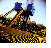
Interstate had turned into state highway, and state highway into farm road and dirt road, when the Bush-Bush rig appeared in the distance, a 150-foot derrick creating the nearest semblance of a skyline to be seen among the pecan groves and fields of young cotton. Up close, Patterson Drilling Company's "Mighty Rig No. 11" looked much as rigs in Texas have looked for decades; it was probably not at all different from the rig that drilled this well the first time around, in 1992. Bush-Bush is on its second life, possibly headed for a third -- as is, for that matter, the whole Giddings field.
Giddings lies above a limestone formation known as the Austin Chalk Trend, which sweeps across southern Texas (through Austin) and Louisiana. The Austin Chalk is a tough, mercurial formation, full of oil and gas but inclined to give them up only reluctantly and sporadically. "Heartbreak Field" some people used to call the Chalk, and Giddings produced only thimblefuls of oil until the early 1970s. Then the OPEC embargo struck, the price of oil shot up, and people began drilling like crazy, assuming that oil prices would never come down and that the good holes would pay for the bad ones. "We drilled all the smart things and half the dumb things," Nathan Meehan, Union Pacific's general manager of technology, told me.
The vertical wells, when they hit, started out strong, but soon their flow dropped sharply. Then came horizontal drilling, and an insight. The oil in the Austin Chalk lay in thin horizontal or gently inclined strata. The strata were marbled with tiny vertical cracks, through which oil could flow from the surrounding impermeable rock. That was why vertical wells struck oil so capriciously and lost pressure so fast: if you were lucky enough to drill down along a crack, you got oil, but the crack soon drained.
In 1987 Union Pacific tried its first horizontal well in the Chalk. That well became known as "Wrong-Way Loehr" and is remembered, not altogether fondly, as a learning experience. The next attempt worked better, and in 1990 Union Pacific felt confident enough to establish a twenty-person horizontal-drilling team. The trick was to find an oil-bearing stratum and nose the drill bit along it, taking care to stay within the pay zone's narrow and often irregular boundaries. The horizontal well would act like a channel connecting all the vertical cracks. "It was the equivalent of adding together eight or ten of these vertical wells,"Meehan said. Moreover, the team could drill a new horizontal well under an old one and hit oil all over again.
(The online version of this article appears in three parts. Click here to go to part one or part three.)
Jonathan Rauch is a senior writer and columnist for National Journal and a writer-in-residence at The Brookings Institution. His most recent book is Government's End: Why Washington Stopped Working (1999).
Photographs by John Acurso.
Copyright © 2001 by The Atlantic Monthly Company. All rights reserved.
The Atlantic Monthly; January 2001; The New Old Economy - 01.01 (Part Two);
Volume 287, No. 1; page 35-49.